COMMUNITY
- COMMUNITY HOME
- HURRICANE IDALIA
- TEACHER HIRING ‘PAUSE’ UNDERWAY EXCEPT FOR LARGE CLASSROOMS
- SCHOOL BOARD RECEIVES MASTER BOARD CERTIFICATION
- SHELL POINT ARTIST GINGER TILLMAN’S WORK DISPLAYED
- STUDIO 88 DANCERS TRAVEL TO DOLLYWOOD
- SOPCHOPPY IS AN OFFICIAL TRAIL TOWN
- ON THE HORIZON
- LIBRARY NEWS
- BUCKHORN NEWS
- WAKULLA STATION NEWS
- CHAMBER NEWS
HURRICANE IDALIA
STORM WARNING
Hurricane may become Category 3 when it arrives on Wednesday

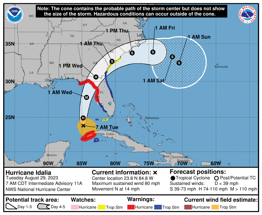
The National Hurricane Center’s likely path of Idalia as of Tuesday.
By JIM TURNER News Service of Florida
Rapidly growing in strength, a potentially devastating hurricane remains on a path to hit Florida’s Gulf Coast.
At tropical-storm strength Monday morning with maximum sustained winds of 65 mph, Idalia was forecast to make landfall as a Category 3 hurricane in the northeast gulf’s Big Bend region Wednesday morning, knocking out power and pushing water ashore up to 11 feet in some areas.
State Emergency Management Director Kevin Guthrie said during a news conference that the storm is moving at a “strengthening intensity,” and people north of Tampa Bay will be affected regardless of the forecast “cone.”
President Joe Biden on Monday approved an emergency declaration and ordered federal assistance in responding to the storm. Gov. Ron DeSantis submitted a request for aid Sunday night to the White House.
Evacuation orders were expected to be issued in Gulf Coast counties, particularly those with barrier islands.
DeSantis, who has shifted focus from his presidential campaign as the storm nears, said there doesn’t appear to be “anything to prevent (Idalia) from continuing to strengthen.”
“We’ve seen this before with something like Hurricane Michael, that continues to gather strength,” DeSantis said, referring to a 2018 storm that caused massive damage in parts of Northwest Florida. “So, this is going to be a major impact and Floridians should expect that this storm will be a major Category 3-plus hurricane. So, please prepare accordingly.”
A storm reaches hurricane strength when maximum sustained winds hit 74 mph. A Category 3 storm produces maximum sustained winds of at least 111 mph.
Duke Energy Florida, which provides electricity in many areas that could be affected by the storm, said Monday it was mobilizing 4,500 workers to help restore power. That included bringing in crews from other states.
“Duke Energy is actively monitoring Idalia’s path, intensity and timing, and staging resources in safe locations to respond to outages as soon as it’s safe to do so,” Todd Fountain, Duke Energy Florida storm director, said in a prepared statement.
DeSantis increased to 46 the number of counties under a state of emergency, up from 33 when a declaration was first issued on Saturday. The counties stretch from Collier County in Southwest Florida to Bay County in the Panhandle.
The National Hurricane Center posted information that said as the storm moved into warm waters of the southeast Gulf of Mexico, conditions were conducive for “rapid intensification,” and the system should keep growing until landfall.
“Idalia is now forecast to become a major hurricane before it reaches the gulf coast of Florida,” the hurricane center said. “The risk continues to increase for life-threatening storm surge and dangerous hurricane-force winds along portions of the west coast of Florida and the Florida Panhandle beginning as early as late Tuesday.”
Tropical-storm-force winds extended outward up to 70 miles from the center of Idalia.
The track remained close to computer models, commonly referred to as spaghetti models, that showed the storm making landfall between the central Panhandle and Tampa.
“It should be emphasized that only a small deviation in the track could cause a big change in Idalia’s landfall location in Florida due to the paralleling track to the west coast of the state,” the hurricane center said.
A storm-surge watch was in effect from Chokoloskee, south of Everglades City, north to Indian Pass in the Panhandle. A hurricane watch was in effect from Englewood in Southwest Florida to Indian Pass. A tropical storm watch was in effect south to the lower Florida Keys, west of the Seven Mile Bridge.
Storm surge was predicted to reach up to 11 feet from the Aucilla River, near Tallahassee, to Chassahowitzka, south of Crystal River, according to the hurricane center. Tampa Bay could see a surge of 4 feet to 7 feet.
The storm’s approach came as Florida grappled with cleaning up at least 29 gas stations — mostly in the Tampa region and Southwest Florida — after gasoline was contaminated with diesel fuel because of “human error” at the Port of Tampa.
“We’re working with (emergency management) to get those fields evacuated and replaced with clean fuel,” Agriculture Commissioner Wilton Simpson, whose department regulates gas stations, said. “By the end of the day we hope to have all of those gas stations identified, with fuel, and which ones can open up.”
DeSantis said officials expect little interruption in gasoline supply as tankers were being staged in Central Florida to help replenish supplies.
